

-

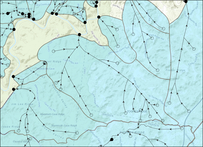
Kentucky Karst Dye Trace Database
This dataset provides the geographical locations of karst groundwater basins, groundwater flowpaths, and dye injection/recovery points in Kentucky. Dye tracing is a common method used for understanding groundwater movement. Dye is poured (or injected) into a sinking stream, well, sinkhole, or body of water, where it is carried down-gradient by flowing water. The locations at which dye is recovered (typically at artesian springs) indicates a connection from injection to recovery site. This connection is refered to as a groundwater flowpath. Conducting multiple dye traces across an area allows for the interpretation of regional groundwater flow by assessing where flowpaths either ...Read More
-
![Kentucky Geological Survey Landslide Inventory [2023-03] by Matthew M. Crawford](https://uknowledge.uky.edu/kgs_data/1006/thumbnail.jpg "Kentucky Geological Survey Landslide Inventory [2023-03] by Matthew M. Crawford")
Kentucky Geological Survey Landslide Inventory [2023-03]
The KGS landslide inventory provides the locations of known landslides and areas susceptible to debris flows. Various types of landslides are represented including slides, flows, rockfalls, and creep. The data are available as ArcGIS geodatabase feature classes. Landslide locations and associated attributes are compiled from Kentucky Geological Survey research, published maps, state and local government agencies, the public, and media reports. A confidence ranking system assigns a value to each feature. A description of the feature classes is here: https://kgs.uky.edu/kgsmap/helpfiles/landslide_help.shtm
The inventory viewed in a GIS with geology, soils, slope or other terrain-based data can serve as ...Read More
-

DVGQ Joint Data
A compilation of digitally vectorized joint data from the U.S. Geological Survey geologic quadrangle maps. Joint data was collected by USGS and KGS geologists using a compass during geologic mapping of the 7.5-minute quadrangle. Field notes of mappers are not available, therefore the orientation of joints was determined by a script written by KGS personnel during the digitization process.
-

KGS Joint Data
Joint orientation measurements collected by KGS personnel at rock exposures from 2009 to 2023. New joint data was collected using a Brunton compass. This data set is a compilation of joints measured by Steve Martin. There are three worksheets related to data structure. The joint location and joint measurement worksheets show a 1-to-many relationship. The 1to1 worksheet shows a 1-to-1 relationship between joint locations and measurements.
-
 by Matthew Massey, Antonia Bottoms, Max Hammond III, Ann Hislop, Meredith Swallom, and Michele M. McHugh")
New Surficial Geologic Mapping in Kentucky (2021-2022)
New surficial geologic mapping was performed in nine new 7.5-minute quadrangles in Hardin, Meade, Breckinridge, Grayson, Hart, and Larue Counties, Kentucky.
Quadrangles include Big Clifty, Big Spring (Hardin county only), Custer (Hardin County only), Flaherty, Madrid (Hardin county only), Millerstown, Summit, Tonieville (Hardin county only), and Upton.
Mapping data for each of the nine quadrangles is captured in a ZIP file that contains an ESRI geodatabase and associated FGDC-compliant metadata files (.xml).
The geodatabase is a relational geodatabase of spatial and non-spatial data that conforms to "GeMS (Geologic Map Schema)--a standard format for digital publication of geologic maps", available at ...Read More
-
 by Benjamin Tobin, Benjamin V. Miller, Matthew Niemiller, and Andrea Erhardt")
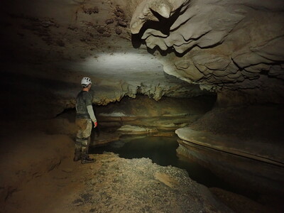
Hydrology Data for Fern Cave, Alabama (2020-2022)
Dataset includes water level from four sites within Fern Cave in Jackson County Alabama. Additionally, it includes chemistry of water, sediments and cave-adapted isopods.
-
![Kentucky Geological Survey Landslide Inventory [2021-01] by Matthew M. Crawford](https://uknowledge.uky.edu/kgs_data/1003/thumbnail.jpg "Kentucky Geological Survey Landslide Inventory [2021-01] by Matthew M. Crawford")
Kentucky Geological Survey Landslide Inventory [2021-01]
The updated version of this dataset is available at https://doi.org/10.13023/kgs.data.2022.01.
The KGS landslide inventory provides the locations of known landslides and areas susceptible to debris flows. Various types of landslides are represented including slides, flows, rockfalls, and creep. The data are available as ArcGIS geodatabase feature classes. Landslide locations and associated attributes are compiled from Kentucky Geological Survey research, published maps, state and local government agencies, the public, and media reports. A confidence ranking system assigns a value to each feature. A description of the feature classes is here: ...Read More
-

Landslide Soil Hydrology Data for Three Landslides in Kentucky
This data is from three landslides monitored in Kentucky between October 2015 and September 2020. The purpose was to capture and analyze subsurface hydrologic conditions within the landslides at different slope positions over time. The site descriptions, field methodology, data-acquisition techniques, and observations provide a general picture of soil moisture in hillslope soils. Data collected includes volumetric water content, soil water potential, bulk electrical conductivity, bulk dielectric permittivity, temperature. Water potential is the energy state of water in the soil, a determination of stress in the soil based on how water moves. Water potential can be described as the negative ...Read More
-

Deepest Observed Fresh Groundwater Contour Lines for the Cumberland Plateau of Eastern Kentucky
These contour lines detail the estimated depth of the base of fresh groundwater—i.e., deepest observed fresh water. These contours were created using the deepest domestic water well depths in each 11-digit HUC watershed of a 14-county study area in the Cumberland Plateau of eastern Kentucky.
-

StateMap 2020-2021: New Surficial Geologic Mapping along the I-65 Corridor in Hardin County, Kentucky
This dataset characterizes the types and distributions of surficial geologic materials in the Cecilia, Constantine, Howe Valley, and Sonora 7.5-minute quadrangles. The primary goal for this mapping project was to identify and map the spatial distribution and understand the mechanical and chemical properties of surficial geologic materials in a rapidly developing area of Kentucky. This new dataset will have immediate utility to a range of users in local, state, and Federal agencies that are working on applications that rely on accurate and detailed surficial geologic data for geotechnical planning, evaluation of water resources, and geologic hazard assessment (karst, landslide, radon).
...Read More
