

-
 by John B. Hickman")
Structure on the Top of Knox Group, Kentucky-Tennessee Mineral District (KTMD)
The deposits of critical minerals within the Kentucky-Tennessee Mineral District (KTMD) are hosted within the Late Cambrian to Early Ordovician carbonate rocks of the Knox Group. To aid in critical mineral assessments of the region, this research project produced a map (digital GIS dataset) of the subsurface structure of the top of the Knox Group: the Knox Unconformity surface. All the input data is from oil/gas well records and exploratory mineral core records because these rocks are not exposed within the study area. Well and core records for the KTMD were acquired from the state surveys of Tennessee and Kentucky ...Read More
-
 by John B. Hickman, Alex M. Washburn, and Georgina Lukoczki")
Map of the Thickness of Ordovician Shales Across the Kentucky-Tennessee Mineral District (KTMD)
The deposits of critical minerals have been found in metalliferous shales. To aid in critical mineral assessments of the Ordovician Shales in the Kentucky-Tennessee Mineral District (KTMD), this research project produced a map (digital GIS dataset) of the thickness (isopach) of the combined Upper Ordovician shale interval across the region. The subsurface input data are from oil/gas well records and exploratory mineral core. Well and core records for the KTMD were acquired from the state surveys of Tennessee and Kentucky. Along with the GIS files, a summary table of the 594 well and core data points used to produce this ...Read More
-
 by John B. Hickman, Alex M. Washburn, and Georgina Lukoczki")
Thickness of Devonian Shale, Kentucky-Tennessee Mineral District (KTMD)
The deposits of critical minerals have been found in metalliferous shales. To aid in critical mineral assessments of the Devonian Shales in the Kentucky-Tennessee Mineral District (KTMD), this research project produced a map (digital GIS dataset) of the thickness (isopach) of the combined New Albany Shale/Chattanooga Shale/Ohio Shale interval across the region. The subsurface input data are from oil/gas well records and exploratory mineral core. Well and core records for the KTMD were acquired from the state surveys of Tennessee and Kentucky. Along with the GIS files, a summary table of the 6,607 well and core data points used to ...Read More
-

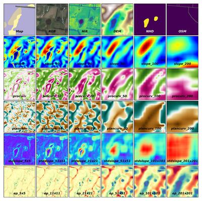
EarthScape AI Dataset v1.1
EarthScape v1.1 Dataset Download Links:
esv1p1_smokeset.zip (197 MB)
esv1p1_splits.zip (2.5 MB)
esv1p1_usa_ky_data.zip (1 MB)
esv1p1_usa_ky_hardin_howevalley.zip (26.3 GB)
esv1p1_usa_ky_hardin_sonora.zip (26.3 GB)
esv1p1_usa_ky_warren.zip (166 GB)
Surficial geologic mapping is essential for understanding Earth surface processes and supporting applications in engineering, hazard assessment, and resource management. However, traditional mapping approaches are labor-intensive, limiting spatial coverage and introducing subjectivity. To address these challenges, we introduce EarthScape, a multimodal, AI-ready geospatial dataset designed for surficial geologic mapping and Earth surface analysis. EarthScape integrates high-resolution aerial RGB and near-infrared (NIR) imagery, digital elevation models ...Read More
-

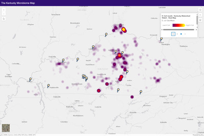
The Kentucky Microbiome Dataset
The Kentucky Microbiome Dataset is a continuously updated geolocated dataset which describes the distribution and diversity of microorganisms across the Commonwealth of Kentucky. Each geolocated point represents a location reported in the peer-reviewed literature where microorganisms were sampled from soil, water, geologic substrates, or clinical settings. Environmental studies include only non-host-associated, non-clinical microorganisms sampled from natural environments. Clinical studies are mapped separately to highlight locations where investigations into host-associated or human health-related microbes have occurred.
For each location, associated metadata include study information, taxonomic classifications, sample type, sampling method, latitude and longitude, sampling date, publication reference, and a direct link ...Read More
-
![Kentucky Geological Survey Landslide Inventory [2024] by Matthew M. Crawford, Evelyn M. Bibbins, and Hudson J. Koch](https://uknowledge.uky.edu/kgs_data/1006/thumbnail.jpg "Kentucky Geological Survey Landslide Inventory [2024] by Matthew M. Crawford, Evelyn M. Bibbins, and Hudson J. Koch")
Kentucky Geological Survey Landslide Inventory [2024]
The KGS landslide inventory provides the locations of known landslides and areas susceptible to debris flows. Various types of landslides are represented including slides, flows, rockfalls, and creep. The data are available as ArcGIS geodatabase feature classes. Landslide locations and associated attributes are compiled from Kentucky Geological Survey research, published maps, state and local government agencies, the public, and media reports. A confidence ranking system assigns a value to each feature. A description of the feature classes is here: https://kgs.uky.edu/kgsmap/helpfiles/landslide_help.shtm
The inventory viewed in a GIS with geology, soils, slope or other terrain-based data can serve as ...Read More
-
 by Matthew Massey")
Kentucky Surficial Geologic Map Compilation Database (Version 1)
The Kentucky Geological Survey (KGS), a state-supported independent research center within the University of Kentucky, is committed to providing accurate and unbiased geologic information on natural resources, environmental issues, and natural hazards in Kentucky. While Kentucky boasts complete coverage by 1:24,000-scale geologic bedrock maps, surficial materials have been largely overlooked, except in regions with thick deposits obscuring the bedrock. Given the increasing trends in economic development and urbanization, detailed surficial geologic mapping has become crucial for supporting geotechnical planning, environmental management, and hazard assessment. In response, KGS has prioritized new, detailed surficial geologic mapping since 2004, specifically targeting areas anticipated ...Read More
-

Earth MRI Western Kentucky Fluorspar District 3D Geological Modeling
The Illinois–Kentucky Fluorspar District (IKFD) three-dimensional (3D) geological data model plays a critical role in the EarthMRI IKFD project, which aims to utilize the vast and detailed geologic maps and datasets that the Kentucky and Illinois state geological surveys possess to develop a Geographic Information System (GIS)-based 3D geological framework model for the district. The model serves as a framework in which to view the subsurface geological and geochemical data, and to better comprehend the structural and other geologic processes acting on the region as they relate to the locations of critical minerals. The development of the model will also ...Read More
-

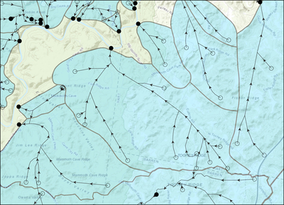
Kentucky Karst Dye Trace Database
This dataset provides the geographical locations of karst groundwater basins, groundwater flowpaths, and dye injection/recovery points in Kentucky. Dye tracing is a common method used for understanding groundwater movement. Dye is poured (or injected) into a sinking stream, well, sinkhole, or body of water, where it is carried down-gradient by flowing water. The locations at which dye is recovered (typically at artesian springs) indicates a connection from injection to recovery site. This connection is refered to as a groundwater flowpath. Conducting multiple dye traces across an area allows for the interpretation of regional groundwater flow by assessing where flowpaths either ...Read More
-

DVGQ Joint Data
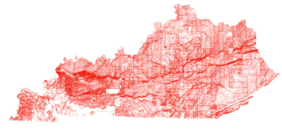
A compilation of digitally vectorized joint data from the U.S. Geological Survey geologic quadrangle maps. Joint data was collected by USGS and KGS geologists using a compass during geologic mapping of the 7.5-minute quadrangle. Field notes of mappers are not available, therefore the orientation of joints was determined by a script written by KGS personnel during the digitization process.
