

Archived
This content is available here for research, reference, and/or recordkeeping.
Researcher ORCID Identifier
Matthew Massey https://orcid.org/0000-0003-3316-9550
Files
Download Full Text (43.6 MB)
Abstract
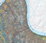
The Newport 7.5-minute quadrangle is located in the Outer Bluegrass physiographic province (McFarlan, 1943) in the Greater Cincinnati metropolitan area of northern Kentucky and includes parts of Kenton and Campbell Counties. Topography is characterized by a relatively broad expanse of upland with moderate relief that is bounded by the Ohio River Valley, Licking River Valley, and Fourmile Creek. Gibbons (1973) mapped the bedrock geology of this quadrangle, which was later digitized by Sparks (2002). The entire quadrangle is underlain by horizontal Ordovician limestone and shale, consisting of the Point Pleasant Formation, Kope Formation, Fairview Formation, Bellevue Tongue of the Grant Lake Limestone, and Bull Fork Formation.
Publication Date
2018
Series
13
Report Number
14
Digital Object Identifier (DOI)
doi.org/10.13023/kgs13ct142018
Spatial Coverage
Newport 7.5-minute Geologic Quadrangle, Campbell County, Kenton County
Funding Information
This map was generated using new field mapping along with compilation of unpublished and previously published data, and was funded in part by the U.S. Geological Survey’s National Cooperative Mapping Program under the STATEMAP program authorized by the National Geologic Mapping Act of 1992, Grant No. G17AC00255, and by the Kentucky Geological Survey.
Language
English
Repository Citation
Massey, M. A., Bottoms, A.E., and Hammond, M. L. III, 2018, Surficial Geologic Map of the Newport 7.5-Minute Quadrangle, Kentucky, Kentucky Geological Survey, ser. 13, Contract Report 14

Methodology
This map was generated using new field mapping, sample analysis, LiDAR elevation data (5-ft average horizontal spacing), aerial imagery, and compilation of data from water-well logs and Kentucky Transportation Cabinet geotechnical reports, landslide inventory mapping from Crawford (2014) and Roenker and others (2018), and outcrop information from Gibbons (1973). Previously published reports by Gibbons (1973), Price (1964), and Weisenberger and others (1973) were also used for interpretation. The map units described here reflect natural processes operating as an integrated dynamic geomorphic system (Newell, 1978). The primary mechanisms of sediment transport and deposition in this area are flowing water (fluvial processes), ice (glacial processes), and gravity/mass movement (colluvial processes), which can be complexly interrelated. Residual soils are interpreted to have accumulated as a result of in-situ chemical weathering of underlying bedrock, soil production, and erosion.