

Research Data--KGS
Researcher ORCID Identifier
Sarah Arpin https://orcid.org/0000-0001-6818-3286
Benjamin Tobin https://orcid.org/0000-0002-0757-9946
Maaz Fareedi https://orcid.org/0009-0002-4750-6968
Files
Download (1.0 MB)
Download Dye Trace Sites (225 KB)
Download Karst Groundwater Flowpaths (318 KB)
Download Karst Groundwater Basins (486 KB)
Download Data Dictionary: Dye Trace Sites, Point Feature Class (1 KB)
Download Data Dictionary: Karst Groundwater Basins, Polygon Feature Class (696 B)
Download Data Dictionary: Karst Groundwater Flowpaths, Line Feature Class (977 B)
Download README (11 KB)
Dataset Creation Date
11/01/2023
Release Date
11-1-2023
Publisher
University of Kentucky Libraries
Description
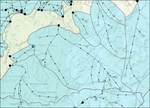
This dataset provides the geographical locations of karst groundwater basins, groundwater flowpaths, and dye injection/recovery points in Kentucky. Dye tracing is a common method used for understanding groundwater movement. Dye is poured (or injected) into a sinking stream, well, sinkhole, or body of water, where it is carried down-gradient by flowing water. The locations at which dye is recovered (typically at artesian springs) indicates a connection from injection to recovery site. This connection is refered to as a groundwater flowpath. Conducting multiple dye traces across an area allows for the interpretation of regional groundwater flow by assessing where flowpaths either converge or remain distinct. Groundwater basin boundaries can then be delineated, however unlike surficial watersheds, karst groundwater basins may differ significantly due to variations in subsurface hydrogeologic configurations and conduit geometries. During periods of increased flow, flowpaths may shift or hybridize with other flowpaths, creating overlapping basins. This dataset can be used for understanding the general flow of karst groundwater but does not guarantee the absolute accuracy of groundwater flow or basin boundaries.
Digital Object Identifier (DOI)
https://doi.org/10.13023/kgs.data.11.09.2023
Rights
© 2023 University of Kentucky. This dataset is distributed under the terms of the Creative Commons Attribution 4.0 International License (https://creativecommons.org/licenses/by/4.0/), which permits unrestricted use, distribution, and reproduction in any medium, provided that the dataset creators and source are credited and that changes (if any) are clearly indicated.
Supporting Information
Most of the DyeTraceSites points in this dataset exist in the publicly-available USGS National Hydrography Dataset (NHD). The field named NHD_Permanent_Identifier in the DyeTraceSites dataset corresponds with the field named permanent_field in the NHD dataset.
File Format
DyeTraceSites.shp KarstGroundwaterFlowPaths.shp KarstGroundwaterBasins.shp DataDictionary_DyeTraceSites_PointFeatureClass_v1.csv DataDictionary_GroundwaterBasins_PolygonFeatureClass_v1.csv DataDictionary_GroundwaterFlowPaths_LineFeatureClass_v1.csv
readme.txt
Relationship Between Files: DyeTraceSites are points which are located along and connect KarstGroundwaterFlowPaths polylines. The points and polylines are generally contained within KarstGroundwaterBasins polygons, when enough data existed to create a basin boundary. Sometimes points and polylines are located at polygon boundaries, due to dye trace studies indicating hybrid groundwater configurations. The Basin_ID field is the relational field between spatial data. Descriptions of attribute table fields are found in the corresponding DataDictionary.csv files.
File Size
1.01 MB
Version
1
Spatial Coverage
Statewide; Digitized or GPS-sourced coordinates of injection/recovery points within karst regions across Kentucky, with a few locations in northern Tennessee where basins overlap state borders. Karst regions within Kentucky are generally divided into three regions: the Pennyroyal Plateau, Bluegrass Region, and Pine Mountain. The Pennyroyal Plateau is further divided into eastern and western subregions.
Temporal Coverage
1925-2023
Language
English
Funding Information
USGS National Geological and Geophysical Data Preservation Program Award Number G23AP00227-01, FY 2023
USGS National Geological and Geophysical Data Preservation Program Award Number G22AP00242-00, FY 2022
Related Content
Data was derived from the USGS National Hydrography Dataset Plus High Resolution, legacy dye trace maps, and recent dye trace reports conducted through 2023. Citations for all sources are listed below.
Blair, R. J., and Evans, R. (2014) Integrated Surface Water and Groundwater Assessment of Large Springs in the Western Pennyrile Karst Region of Kentucky. Retrieved from https://eec.ky.gov/Environmental-Protection/Water/Reports/Reports/NPS0704-BMU3R2.pdf.
Crawford Hydrology Lab. (2023). Glenns Creek Dye Trace Investigation Woodford and Franklin Counties, Kentucky. Bowling Green, KY.
Currens, J. C., and Blair, R. J. (2016). Mapped Karst Groundwater Basins in the Elizabethtown 30 x 60 Minute Quadrangle. Map and Chart 212. map, Lexington, KY; Kentucky Geological Survey.
Currens, J. C., and Ray, J. A. (1998). Mapped Karst Ground-Water Basins in the Somerset 30 x 60 Minute Quadrangle. Map and Chart Series 18. map, Lexington, KY; Kentucky Geological Survey.
Currens, J. C., Paylor, R. L., and Ray, J. A. (2002). Mapped Karst Groundwater Basins in the Lexington 30 x 60 Minute Quadrangle. Map and Chart 35. map, Lexington, KY; Kentucky Geological Survey.
Currens, J. C., Paylor, R. L., and Ray, J. A. (2003). Mapped Karst Groundwater Basins in the Harrodsburg 30 x 60 Minute Quadrangle. Map and Chart 58. map, Lexington, KY; Kentucky Geological Survey.
Currens, J. C., Paylor, R. L., Blair, R. J., and Walden, W. (2018). Mapped Karst Groundwater Basins in the Corbin 30 x 60 Minute Quadrangle. Map and Chart 1. map, Lexington, KY; Kentucky Geological Survey.
Currens, J. C., Paylor, R. L., Ray, J. A., and Blair, R. J. (2011). Mapped Karst Groundwater Basins in the Somerset 30 x 60 Minute Quadrangle. Map and Chart 202. map, Lexington, KY; Kentucky Geological Survey.
Currens, J. C., Ray, J. A., O’Dell, P. W., and Blair, R. J. (2015). Mapped Karst Groundwater Basins in the Hopkinsville 30 x 60 Minute Quadrangle. Map and Chart 205. map, Lexington, KY; Kentucky Geological Survey.
Fareedi, M., Parada, C., Tackett, K., and Tobin, B. W. (2023). Sinking Fork Creek Dye Trace Report. Lexington, KY; Kentucky Geological Survey.
O’Dell, G., and Currens, J. C. (2018). Mapped Karst Groundwater Basins in the Morehead 30 x 60 Minute Quadrangle. Map and Chart 3. map, Lexington, KY; Kentucky Geological Survey.
Ray, J. A., and Currens, J. C. (1998a). Mapped Karst Ground-Water Basins in the Beaver Dam 30 x 60 Minute Quadrangle. Map and Chart Series 19. map, Lexington, KY; Kentucky Geological Survey.
Ray, J. A., and Currens, J. C. (1998b). Mapped Karst Ground-Water Basins in the Campbellsville 30 x 60 Minute Quadrangle. Map and Chart Series 17. map, Lexington, KY; Kentucky Geological Survey.
Ray, J. A., and Currens, J. C. (2000). Mapped Karst Ground-Water Basins in the Bowling Green 30 x 60 Minute Quadrangle. Map and Chart Series 22. map, Lexington, KY; Kentucky Geological Survey.
Ray, J. A., Blair, R. J., and Currens, J. C. (2018). Mapped Karst Groundwater Basins in the Louisville 30 x 60 Minute Quadrangle. Map and Chart 4. map, Lexington, KY; Kentucky Geological Survey.
Ray, J. A., Moody, J. R., Blair, R. J., Currens, J. C., and Paylor, R. L. (2009). Mapped Karst Groundwater Basins in the Tell City and Part of the Jasper 30 x 60 Minute Quadrangles. Map and Chart 196. map, Lexington, KY; Kentucky Geological Survey.
Taylor, C.J., and Tobin, B.W., 2020, Water quality and quantity data for edge of field monitoring in a sinkhole dominated karst landscape, The Homeplace on the Green River: Kentucky Geological Survey Research Data, https://doi.org/10.13023/kgs.data.2020.01.
Tobin, B. W. (2023). Baseball Diamond KW, CV Weddle KW, Allen Cave Spring. map, Lexington, KY; Kentucky Geological Survey.
U.S. Geological Survey, (2023). National Hydrography Dataset Plus High Resolution (NHDPlus HR) - USGS National Map Downloadable Data Collection.
Recommended Citation
Arpin, S. M., Fareedi, M., Link, A., Currens, J., Tobin, B. W., 2023. Kentucky Karst Dye Trace Database: Kentucy Geological Survey Research Data, http://www.doi.org/10.13023/kgs.data.11.09.2023

Notes
Quality-Assurance Procedures Performed on the Data:
DyeTraceSites.shp The injection/recovery sites were reevaluated to confirm whether they were injection points, recovery points, or both based on the original data. Points were connected to groundwater flowpath lines, showing continuity from injection site to final recovery point.
KarstGroundwaterFlowPaths.shp Groundwater flow path line topologies were readjusted to maintain seamless continuity from injection sites to recovery sites.