

Archived
This content is available here for research, reference, and/or recordkeeping.
Validation of a Portable High-flow Methane Measurement Protocol for Orphaned Wells [Supplemental Information]
Files
Download Data_Dictionary.xlsx (105 KB)
Download README.txt (12 KB)
Download Supplemental_FarApart_Compilation.xlsx (4.4 MB)
Download Supplemental_Fluted_Compilation.xlsx (2.0 MB)
Download Supplemental_MasterSummary.xlsx (215 KB)
Download Supplemental_Methane_Weather_Descriptive_Statistics_and_Correlations.xlsx (442 KB)
Download Supplemental_OpenHole_Compilation.xlsx (2.0 MB)
Download Supplemental_TwinLeaks_Compilation.xlsx (2.0 MB)
ORCID(s)
Washburn, Alex 0000-0002-6260-477X
Dataset Origin Date
11/2/2026
Version
1.0
Version Publication Date:
11-10-2026
Abstract
This dataset documents controlled methane-release experiments evaluating the effects of tarping and simulated wellhead configuration on high-flow methane measurements. Experiments were conducted outdoors at the Kentucky Geological Survey Earth Analysis Research Laboratory in Lexington, Kentucky. The dataset includes 90 experimental test blocks and 62 controlled-release standard blocks across four configurations: far apart, fluted, open borehole, and twin leaks. Tests used methane mass-flow targets of 79.9, 39.9, and 0.86 g/hr under tarped and untarped conditions. Four compilation workbooks contain retained instrument time series, trim indicators, weather observations, and charts. A master workbook contains block summaries, standard-based corrections, descriptive statistics, and comparisons. A weather workbook contains Kentucky Mesonet observations, interpolation calculations, test-level weather summaries, and exploratory correlations with methane capture and measurement variability. These data support evaluation of methane measurement accuracy and precision under the tested conditions.
DOI
https://doi.org/10.13023/kgs.data.11.10.2026
File Format(s)
Six Microsoft Excel workbooks (.xlsx), README (.txt), and data dictionary (.xlsx).
File Size(s)
- Supplemental_FarApart_Compilation_v2.1.xlsx: 4,584,677 bytes
- Supplemental_Fluted_Compilation_v2.1.xlsx: 2,138,562 bytes
- Supplemental_MasterSummary.xlsx: 220,472 bytes
- Supplemental_Methane_Weather_Descriptive_Statistics_and_Correlations.xlsx: 453,004 bytes
- Supplemental_OpenHole_Compilation_v2.1.xlsx: 2,105,953 bytes
- Supplemental_TwinLeaks_Compilation_v2.1.xlsx: 2,124,729 bytes
Geographic Coverage
KGS Earth Analysis Research Laboratory, Lexington, Fayette County, Kentucky, USA. Weather: Kentucky Mesonet Spindletop (SPIN), Fayette County.
Data Collection Period
February 25–March 19, 2026
Data Collection Method(s)
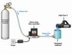
Gas containing 40% methane was supplied through an Alicat Scientific mass-flow controller to four simulated wellheads open to atmospheric pressure. Methane was measured with a SEMTECH HI-FLOW 2 sampler. Three approximately 10-min replicate blocks were measured for each configuration, tarp condition, and target flow rate. Far-apart tests included both intake positions, producing 36 blocks; each other configuration produced 18 blocks. Approximately 3-min standards were measured with the supply tube placed close inside the sampler intake. Eighty-seven tests had pre- and post-standards; three untarped twin-leak tests at 0.86 g/hr had a pre-standard only.
Block means and sample standard deviations were calculated from retained measurements. Raw capture or recovery (%) = mean measured methane / known methane × 100. Within-test CV (%) = sample SD / mean measured methane × 100. Standard recovery was linearly interpolated between standard midpoint times to the test midpoint. Correction factor = 100 / standard recovery expressed in percent; corrected flow = raw mean × correction factor. Pre-only tests use the preceding standard. Corrected recovery (%) = corrected mean / known methane × 100. Signed bias = measured minus known; percentage bias divides this difference by known flow and multiplies by 100. Absolute percentage error is the absolute value of percentage bias. Weather analyses use raw methane capture and raw measurement CV, rather than corrected recovery.
Kentucky Mesonet Spindletop station (SPIN), Fayette County, supplied weather observations at approximately 5-min intervals. Weather was aligned to local test timestamps. Linear interpolation between adjacent observations was integrated over each full test interval to obtain time-weighted mean conditions. Wind variability CV (%) = time-weighted mean of station-reported wind-speed SD / time-weighted mean wind speed × 100. This is not the SD of the sequence of mean winds divided by their mean. Maximum recorded gust uses available station gust observations within a test interval, rather than an interpolated maximum. Mean precipitation is a mean of reported interval values, not a total storm or test accumulation. Weather correlations are descriptive Pearson correlations; weather conditions were not balanced among test groups.
See README.txt and Data_Dictionary.xlsx for variable definitions and file organization.
Disciplines
Geology
Originator(s) of Data Set
Washburn, A. M., Zierer, D., Walton, Z. O., Hawksley, A., Rivers, M., and High, M.
Current Point of Contact
Alex M. Washburn
Funding Information
Kentucky Energy and Environment Cabinet, Division of Oil & Gas
Related Content
Associated manuscript: Validation of a Portable High-flow Methane Measurement Protocol for Orphaned Wells, in review.
Rights Information
© 2026 University of Kentucky. This dataset is distributed under the terms of the Creative Commons Attribution 4.0 International License (https://creativecommons.org/licenses/by/4.0/), which permits unrestricted use, distribution, and reproduction in any medium, provided that the dataset creators and source are credited and that changes (if any) are clearly indicated.
Archival?
Accessible
Recommended Citation
Washburn, A. M., Zierer, D., Walton, Z. O., Hawksley, A., Rivers, M., and High, M. (2026). Validation of a Portable High-flow Methane Measurement Protocol for Orphaned Wells [Supplemental Information]. Kentucky Geological Survey, University of Kentucky, UKnowledge. Version 1.0. DOI: https://doi.org/10.13023/kgs.data.11.10.2026